Flying Adventures of the Eager Beaver

These are the tracks that I flew in the little Eager Beaver,
Four long trips 1995-'98 and many visits to Narromine.

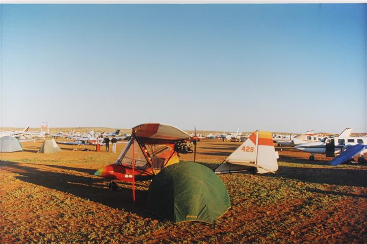
Single seat, empty weight 176kg, 40hp 2-stroke, 50kts cruise, 30 kts stall, range 250nm.
My aircraft is a single-seat Beaver RX28, manufactured by Spectrum Aviation in Canada, and it's just perfect for the coming adventure. It first flew in 1984 and the original owner Jim Sloan of Wangaratta had a lot of fun putting 600 hours on it. I did a complete strip down and overhaul, replaced the Rotax 277 with a 447 so it's now really an RX40, added bigger wheels, brakes, steerable nosewheel, and generally fitted out for traveling the outback. That included adding two 20 litre jerry cans as extra fuel tanks. They sit right on the C of G , and are secured with specially made straps that can be unbuckled to carry them to a petrol station - it works great.

..................................................................................................
Beaver to Birdsville and Back

The familiar valleys were now behind, and the countryside
below opened out into the broad fields of the Darling Downs. The low cloud was
rising and the sun was breaking through as I left the coastal ranges behind and
headed west. This was starting to feel like an adventure and so it should be, I
was headed for the Birdsville Races!
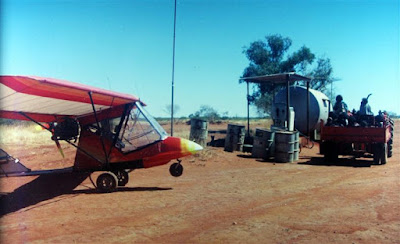
Roma has a pump with mogas right on the field, so it's an
easy fuel stop. Scoff a meat pie, empty
the ‘comfort’ bottle, and head on out - as soon as the Prime Minister gets out
of the way in his VIP jet. He's been up
here to promise the farmers some rain, and now he's off to promise something
else somewhere else, so I had better not get in the way of such important
business.
The cultivated
paddocks are soon behind, and even rough clearings are getting scarce. By 50 miles before Charleville there are no
clearings at all anymore; this is the start of mulga belt. Cruising at 4500 feet, the road is the only
option now - it looks quite narrow from up here, and quite busy. This is ‘bunyip country’ ( we don't have tigers in this country, but
we do have bunyips down there, so I think the term should be changed) was the
most worrying section of the whole trip.
The big Charleville airfield sure is a welcome sight. Luckily someone is at the local Aero club,
and there’s a drum with some fuel to spare.
Otherwise it's a long run into town to a service station. Still plenty of daylight, but it would mean
flying straight into the sun, so I camped on the soft lawn of the flying
club. In the evening, local astronomers
set up telescopes near the airfield and give visitors a look at the heavens.
Away early for Quilpie.
Still solid mulga country, but at least the road is deserted now. The country is opening up as I near Quilpie. Don't really have to stop here; I have enough
fuel to make Windora - if there's no headwind, but if so there’s no
alternate's along the way. Quilpie has a
fine, deserted airfield right beside down.
By taxing to the end of the runway, climbing a fence, past stockyards,
negotiating with the dogs belonging to the railway workers, and over the
tracks, it's only about 200 m to the fuel depot. A meat pie at the bakery then away.
West of Quilpie the country really opens up - lots of grader
tracks and claypans, so flying lower and enjoying the scenery. Landed at Windora just after the scheduled
RPT departed. A woman was mowing a tiny
patch of lawn around the terminal as I unpack my jerry cans to go a couple of
miles to town for fuel. She finished
mowing and then turned on a sprinkler to grow the grass again, then jumped in
her 4WD and headed into town - no offer of a lift…. I carried the jerry cans out to the road and the
first car to pass gave me a lift. When
we got to the petrol station her 4WD was there!
It seems that’s also the agency for the airline. The fellas who gave me the lift were ‘snowbirds’
(retired Victorians migrating from the southern winter), and they had lots of
time to spare. So they drove me out to
the strip again. They hung around, envious
as could be, as I packed up. I encouraged
them to find a CFI and start training when they get home, but they lamented
that they were "…too old and had missed their chance…". Well I guess if they think that way then it
is too late, but I certainly don't want to sit around all my life, and then
spend old age in regret.
Flew away into the afternoon sun, to the ruins of the old
J.C. Hotel, dating back to 1880. No airstrip here, but did a
careful precautionary then set it down.
My first off-field landing, what a buzz!

Had a good fossick around all the old mementos. The walls were made of rammed earth, in the
mid-1800’s, and only the bases still survive.
The remains of an early truck with contracting band drum brakes, a
graveyard with marble headstones dating from 1894, along with more recent
graves marked only with old steel fence pickets.

Another story of fading prosperity and broken
dreams. Millions of old-style beer
bottles; a cause or just a symptom of the decline??? Camped on the site, but no ghosts came to
visit.
Next morning I walk the take-off run carefully, picking up
any of those sharp, twisted mulga roots that would be such a danger to a tire,
or maybe flipped up into a pusher prop.
The take-off would have to be straight into the rising sun so
not much visibility, so better check it out well before hand. Up and away, nearly blind, then a turn to the
west and the golden early light makes the country look spectacular!
Lots of open country now - it's all one big airstrip for
a little aircraft like this. Flew hither and thither, exploring the
country and checking out waterholes and bores.
This sort of flying sure confuses dead reckoning navigation, but the
road is to the north, and curves around in front, so it won't be hard to find.
Landed on the long gravel strip right out the back of
the Betoota pub. Tried to taxi around to the petrol pumps, but gate post in the way.
The publican and said, "Why didn't to land on the road, everybody
else does!" This is a fair dinkum
outback pub that really deserves another visit and a stop over. I have a feeling that a night spent there
would add some more memorable stories to any repertoire.
Approaching Birdsville was a bit of a tense time. The AIP supplement warned about the heavy
traffic in circuit and stressed, "...
At 10 miles out reduce speed to less than 120 kts!..." But the radio was completely silent, (was I
on the wrong frequency???). I don't
enjoy mixing with high-speed traffic at the best of times, but this was ominous... When I got in sight of the airfield, the
reason was clear - it was deserted - I was the first aircraft to arrive!

First sight of Birdsville, flooding in the creek from recent rain.
The vast, empty, dusty, parking area looked a bit lonely, so
I flew on out to ‘Big Red’, the highest sand dune, and landed on a claypan on
the western side of it.

Big Red

Camped at Big Red
Now this is the
sort of adventure I'd come for! I like
to think of my little aircraft as a high clearance trail bike, and now it was
proving its worth many times over. I was
just walking over to climb the dune when three four-wheel drives rumbled in
from the Simpson Desert. I stuck out my
thumb and hitched a lift to the top; the most unusual ride that I've ever
hitched! As we visited on the top of Big
Red, one of the drivers demonstrated his GPS, and convinced me that I really do
need one. I enjoy conventional
navigation, but out here the distinctive features are few and far between, and
an error could be more than just embarrassing, so I'll have one next time.
Next morning it was blowing hard from the NW, so not enough
fuel reserve to make it to Poepell's Corner, so headed back into Birdsville and
join the action.
And what a lot of
action, it was! For those overseas, Birdsville is a tiny town (approx 100) in remote Australia that's the site for a popular annual fly-in coinciding with bush horse races. A couple of hundred planes, many from the big cities, some looking forward to a wild time out of sight of colleagues..... Proceeds to the Royal Flying Doctor Service
Normally I avoid big booze-ups,
but this was different. A tremendous a
lot of drinking going on, but all in good humour. The only fights I saw were in Fred Brophy's boxing
tent, and at the cue for the telephones (no mobiles in those days). By midnight, the whole street was deep with empty tinnies. At 4 AM a big street sweeping machine roared
in and sucked them all up. It's a
memorable sound, thousands of cans clattering around inside that giant vacuum
cleaner! I was parked on the tarmac
right in front of the pub, so I heard it all in living stereo.

In front of the Birdsville pub.

Fred Brophy's Boxing Tent every evening.
You have to be right up front and put up with the crush to get in, but it's worth every bit of it.
He travels around with a troupe of boxers, and challenges locals to try to beat them.
Plenty of rough and tough country boys come out of the crowd to have a go.
And there's some good fights, all in good fun, nothing nasty.
A really good documentary here Fred Brophy's Boxing Tent
A really good documentary here Fred Brophy's Boxing Tent
It blew 15 kts northerly all that day, so I stayed tied down
to the cables on the tarmac in front of the pub. This was supposed to be just for the guests at the pub, but the ground in the
parking area was too hard for my pegs, so I
claimed the first-come-first-serve, and stayed on. Lucky I did, because that evening when I came
out of the boxing show, the breeze had shifted to a southerly. By the time I turned the aircraft around, the
street lights disappeared in a haze of dust, the sand blew everywhere as a
southerly buster the roared through. I
hesitate to estimate wind speed, but to blow that much sand that high, it was
really howling.
The aircraft was rearing back and lifting the cables a few
inches, increasing the angle of attack even more – creaking and groaning, something was going to break. So I lifted the tail into a cruising
attitude, and it immediately it settled down.
Then an ultralight flyer, who had come by road, saw the dilemma and came
to help (I forgot your name mate, but thanks a lot for your help!). He held the tail up while I climbed into the
seat and tied the stick forward. Then he
could let go and the aircraft stayed happily at this attitude. Now the aircraft had no tendency to fly off
at all; the fabric on the bottom of the wing was slack. Of course, this is because this aircraft has
that excellent landing gear arrangement that is both tricycle and tail dragger,
with the mains right at the CofG; a pure
tail dragger would be too heavy in the tail to rise like this. So I spent the night ‘flying on the ground’ -
lucky this is such a comfortable seat.
Actually, it was at least as comfortable as a 747 seat, without having
to compete for elbow room! That
experience showed me that I needed much better tie-downs - can't always count
on having cables. The ‘Screw-Its’ tie-downs that I used to manufacture are a direct result of that wild night.
While parked at Birdsville
and talking to GA fliers, the first question was always "…How long did it
take you to get here?...”. When I
answered, 17 hours, they seemed appalled at the thought, and considered it to
be a feat of endurance, but really it was 17hours of pure delight. All those GAs going straight through at 8000
feet, missed out on all this fun and adventure.
Really, this aircraft shouldn't be compared to high-speed fixed wing
aircraft at all, but rather to a helicopter.
With a landing/takeoff roll of only about 50 m, and great climb-out performance,
it's not much short of the capabilities of a small helicopter. Dick Smith knows how much fun it is to
explore the outback in a helicopter - I was getting that same fun, for a
fraction of the cost!
The little aircraft attracted a lot of interest, and I'm
sure that several of those visitors, especially the motorcyclists, will go for training
when they get home and maybe get hooked on ultralights.
It turns out that Sunday is the really heavy traffic day, as
everyone heads for home, so I left the action on Saturday. Slim Dusty sings nostalgically of, "...
mustering on the Arrabury Plain…”
(That's a bit north of Innaminka.")
Now here I was, cruising over it at 500 feet AGL. There’d been a bit of rain recently, which
brought a flush of colour to the ground, and in the late afternoon light the
scene was really splendid. My normal
cruising speed is 50 kts, but now I was throttled back to 40, just to enjoy the
experience for longer!
At Innaminka the ground was too hard for pegs, and so I tied
to a fence, Innaminka has free public, hot showers and laundry facilities, much
appreciated. While laundry dried on the
fence, I flew out to check out the Coombie Lakes, the big waterholes along the
Cooper, and Moomba gas fields. Refueling
at Innaminka I talk to more four-wheel drivers about ultralights, and by the
excitement, I reckon some will follow-up and go for training as well.
The DIG tree already had a couple of four-wheel drives
camping there, so I flew back down the Cooper Creek to the to the Qld/SA border
and found a claypan. This border is
really distinctive from the air - there are two parallel dingo fences
disappearing into the distance. I'm told
there was some political squabble about funding between the states, so each
built their own fence!
Even with the machinery of today it would be a big project,
but imagine the effort needed to move all the men and materials through that
difficult country in those days - and then double it. What a make-work project. Maintenance was abandoned long ago, then weeds
blown against the wire blocked the drifting sand, so now we have two perfectly
straight sand dunes to show for all that effort.

It sure is great having a versatile little
aircraft like this to explore this unique history! A faster aircraft would zoom
by high overhead and miss it all.
I rolled out my
sleeping bag beside the fire and had another really comfortable night. Self-sufficient camping by ultralight means
traveling light, but that's the best way to go anyhow. All you really need is a bedroll, a billy,
and a bag with some Tucker. The swaggie used
to carry it slung on his shoulder, but now it seems that even a large
four-wheel drive isn't enough for many travellers, so you see stuff piled on
the roof or pulled in a trailer - what a load to carry around, and pack/unpack!

Every claypan is an airstrip.

It's so much easier to travel light. Modern backpacking gear is so lightweight
that I can also carry a self-inflating mattress - the swaggie of old wouldn't
believe the luxury! The water is the
heavy bit. I carried 8 L, but never
needed to open the 5 L container. It's
so much easier to find waterholes and bores from the air them from the
road. If there are cattle or sheep down
there, then there must be water not too far away, and with an aircraft like
this, any bit of vehicle track makes a landing strip.
Speaking of outlandings, this area has lots of flat, dark
brown plains that look fine from the air.
But get right down to have a closer look, and they turned out to be
gibber plains. That is, rocks,
continuous rocks, lots of them as big as melons - the sort of stuff that would
tear the wheels off any aircraft.
Instead, look for the light gray claypans – they’re excellent landing
areas. Stay away from the white salt
pans! I knew to be wary of them, but
feeling cheeky, went to skim one and check it out for myself. I was right out near the edge of the pan, and
was just going to touch and go, but when the wheels touched there was a sudden
deceleration and a sickening feeling that I'd blown it.... Full power and plowing through that soft mud... Only saved by the massive thrust of that big
slow turning prop. Whew!! Back home, Artie Hearn, who spent many years
flying an Auster in and out of the remote corners of this desert, told me a
much better way to touch and go. Fly a
few inches above the surface at an airspeed, well above best glide speed, then
rock the aircraft to touch one wheel at the time - it's a lot easier to lift
one wheel out of the muck than to lift the whole aircraft. Then go round again and have a close look to
see what marks the wheels left. I left a couple of long furrows in the mixture
of salt and mud.
Next stop was the Noccundra pub. There's a big gravel strip and a taxiway
right up to the fuel pumps. This old
stone pub dates back to before the turn-of-the-century, and used to have a
great character with little changed since those days, when I was here by road
only a few years ago, but now it's been renovated into a boutique pub, like
you'd find in one of those arty crafty tourist towns. In the lounge bar, a large TV set was tuned
to weight-loss aerobics on daytime TV...
Is that progress?? Just a few
years ago, they were celebrating the installation of their first
telephone!
The next stop was meant to be the Yowah opal fields, and to
have a soak in their steaming hot artesian bore water.

Diggings for opals.
I'd remembered an open area near the shop and
petrol pump that would do for landing, but since then they've got electric power,
and now there's wires everywhere...
Progress..... So on to Eulo. We're now back into really thick ‘bunyip country’, so Eulo is a really welcome
island in the mulga. And Eulo really is
worth a stop if you're going this way.
It looks like a tidy town winner, which is most uncharacteristic for
small towns out this way. The airfield
parking area is only a short walk from the fuel and the pub. The pub has a colourful history from the opal
mining boom days, and lays on a really good feed these days.
Next morning I headed east the same time as this fast-moving
squall.

Paced that storm for the next
three hours at 50 kts. Looking behind
just to be sure it wasn't closing in, but it stayed south of the road, while I
stayed north of the road. Everything was
fine until just before St. George, where the road takes a jog to the south,
putting the town right in the path of the storm. Full throttle at 65 kts I was just able to
make the airfield and taxi directly into the Jones Ag Air hanger before they
closed their doors. I guess it must've
looked pretty risky and dramatic from down there, but I knew it was still all
clear to the north, so I could've turned and gone that way any time and let the
storm go by. Must always have at least
one good option...
The last night was in a real bed at the Cobb & Co. pub
in St. George. I had intended to go
straight home, but the fast-moving front caught up at that point. So instead, I spent another memorable
evening, this time swapping yarns in a warm and friendly pub, with four-wheel
drivers also on the way home from Birdsville.
If I'd been in a fast ‘tinnie’ I’d' have been home already, and back
into the hassles of everyday life, so I was thankful to be stranded here one
more night. Next day I rode the strong
SW tailwind, and all too soon was back home.
Back to home base at Kilcoy, SE Queensland.
I wouldn't have missed that Birdsville trip for anything,
and what's more, I wouldn't trade my little 95.10 aircraft for any of the flash
machines out there, regardless of cost.
They just can't get me into the places I want to go and do the things I
want to do.
Radio communications were surprisingly good all the way. The tiny handheld Icom VHF, properly
installed and hooked up to a good external antenna, gave dependable contact
with flight services while at altitude.
With the amount of traffic on the area frequency I'm sure I would have
been able to contact another aircraft from the ground if necessary. I reported to friends back home, whenever a
telephone was available, and kept a de facto SAR time going that way. I also filed SAR times with Flight Services
on a couple of legs. But I put most value
on the contacts with local people along the way.
I carry an ELT - just in case, but, surprisingly, most
usable of all was the UHF radio. With truckies, four-wheel drives, road crews,
fencing crews, and station vehicles, including a station Cessna, I was nearly
always in touch with those locals who would've been the most useful in an
emergency. This may seem like a remote
and uninhabited area to you, but it's home for these people and just as
familiar to them as your area is to you.
They have their ways of staying in touch while working in this country,
and know how to move around it easily, so it's this network that I want to be
in touch with. I used to work in oil
exploration, and I have had to find my way into many remote areas, from the
Arctic to the Amazon. (There’s a saying,
"Join an oil exploration crew, and see the swamps and deserts of the
world.") In most cases I've found
it much better to arrive in the area and then seek out the local hunters/fisherman/farmers/traders,
and use their knowledge and means of transport, rather than to try to plan it
all from afar. Same goes for here. This was before I had a GPS. Navigation was usually just follow the
road. The main roads mostly run directly
from one fuel stop to the next, so it made good sense to stay near them.

The dust clouds from the four-wheel drives bashing away over the corrugations made me glad to be traveling in a real high clearance vehicle.

The dust clouds from the four-wheel drives bashing away over the corrugations made me glad to be traveling in a real high clearance vehicle.

..........................................................................................................
The High-Clearance Trail Bike goes to Birdsville Again
Sept 1996
It's been a long day since leaving my home airfield
at Kilcoy, Southeast Queensland. 9.3 hours of flying time, and most of it
lumpy, so it's a great pleasure to walk
on solid ground and hear the silence. It’s
sundown, and I’m at Cooladdi Roadhouse, west of Charleville, after landing my
little Beaver ultralight on a dirt track near the cattle yards.
Yes, I'm on my way to
Birdsville again, with my high clearance trail bike. I enjoyed the trip so much last year, that I
just had to go again. I'd like to spend
a couple of months flying around out here, but other commitments mean this is
going to have to be just another quick trip (at 50 kts I guess ‘quick’ is
relative).
Away early and overfly Quilpie. The air is clear and steady, so it's
hands-off – delightful flying! Later, I
feel drowsy is coming on, so land on the old abandoned airstrip near Thylungra
Station and have a nap in the shade of the wing. Now this is really becoming a holiday!
Windorah airfield is
busy with GA aircraft on their way to the races. The road is also busy, so it's easy to get a
lift into town for fuel and a steak sandwich.
Next stop, Betoota. I have enough
fuel to get all the way to Birdsville, but the airstrip right behind the pub
makes this a very convenient stop, as always a good feeling to have lots of
fuel reserve. The place is really
hectic, with travelers headed for the races.
What a contrast to the rest of the year!
The road below was a continual cloud of dust from the
vehicles heading into the westerly sun, except where the recent heavy rain had
flooded the claypans, and then they were busy pulling each other out of the
bogs. Once again, I was glad to be in a
real high clearance vehicle. 500 feet is
a good minimum clearance for some of these corrugations down there!
Could've made it to Birdsville just at sundown, but the VHF
radio showed lots of incoming GA traffic hurrying to get down before last
light, and since there was going to be more than enough talk and socializing in
the days to come, I decided to have one more quiet night in the open. So I landed on the enormous Roseberth Station
airstrip, and had another peaceful and memorable night under the wing of my
great little aircraft. Next morning away
at sunrise, and with only 16 miles to go, I was the first aircraft of the day
into Birdsville.

Mine was the only ultralight at Birdsville again this year,
so it attracts a fair bit of attention.
That's just fine, because I unashamedly take every opportunity to tout the
delights of flying 95.10 aircraft. So it
was particularly heartening this year, to meet again a biker I’d converted last
year, and hear that he's now taking ultralight training, and is hooked!
The ‘entertainment’ was the same as always out there - a big
booze up.
I have no interest at all in horse racing, so haven't even
been out to the race track, and wouldn't be the only one either as the crowd around
the pub only got a bit less when the racing was on - you still couldn't breathe
inside, but you could at least find a place to sit on the curb!
Fred Brophy's boxing tent starts up in the evening, and
seems to attract more excitement than the races. Of course I was right up front to get a good seat this time. And as I've noted
before, it seems unusual, with all that drinking going on, to have no fighting
in the street (except in the que for the telephones); maybe that boxing tent
acts as a safety valve.
Sunday morning, clouds of dust as the 250 aircraft started
up and is queued for departure. On the
VHF I heard one aircraft cancelled his SAR time only 10 minutes out, and
announced that he was returning to Birdsville, “…due to ill passenger on board…”. I think quite a few of them up there wouldn't
have been really recovered from the night before…...
I've found a slot in the queue and took off, but didn't
headed east with the flock. I was headed
west, Peopell’s Corner, in the Simpson desert, where Queensland, South
Australia and the Northern Territory all meet.
I'd been too ‘Big Red’ the largest sand dune at the start of the desert
last year and landed on a nearby claypan at that time. Now, it was all underwater due to rain!


The old seismic survey line, designated the QAA line, that
serves as the track into the Simpson desert, runs dead straight to the western
horizon, through an ocean of sand dunes.
There's no other sign of civilization in any direction. Now this is really starting to feel like an
adventure! It's only two wheel tracks in
the sand, so you don't have to be very off to the side and it becomes
invisible. In the beginning there were
frequent claypans between the large dunes, but these out-landing spots got
fewer and fewer, until the last 20 miles or so were all small dunes, with only
hummocky red sand and tough scrubby bushes in between. Not inviting country for a single ignition
two-stroke engine.
Landing on the sloping backside of a dune would be the best
bet, but takeoff again wouldn't be possible.
I had dreamt for some time following the French Line right across the
Simpson Desert, by arranging a fuel dump along the way, but it didn't look like
such a good idea now. Four-wheel drivers
coming in out of the desert said there are vast areas of those small dunes with
no claypans between. I've had 450 hours
without a miss from this great little 447 Rotax, and it’d only take another
four hours to get right across, so the chances would seem to be good; but it
still could happen at any time, so it just wouldn't be prudent, especially
without ground support.
At Peopell’s Corner is a large dry (??) salt lake that aircraft have used often
before, but wheel tracks showed that four-wheel drives had been bogged here
since that recent rain. A touch and go
left some nasty looking ruts in the surface, even though it felt firm enough
underneath, but then the salty soil does tend to ‘fluff up’ when it dries out
after a soaking. It sure is a ‘hold your
breath feeling’ to settle down onto such an unknown surface in such a remote
location.

But no problems this time.
There are plenty of well-equipped four-wheel drives passing this way,
that could give assistance if needed, but a bent aircraft would be a real
hassle. Taxied into shore and found a
track packed down by vehicles that would make a better takeoff strip. The 12 knt headwind on the way out had used
up the fuel that I was hoping to have for local flying, so spent the rest of
the day exploring on foot, and trying to learn the signs that indicate the
firmness of the salt pans. But no real
good signs that I could find. Then another delightfully silent night under the stars, beside a small, steady fire
of gidgee coals.


Next morning and
still blowing NW, and so rode the tailwind back to Birdsville. On arrival found the place deserted, except
for one very despond GA pilot. When he
had started up to go back to Melbourne he discovered a bad magneto. Now a mechanic was going to have to fly all
the way from Charleville to fit another one.
The cost of running a GA tinnie…...
The locals in Birdsville say another front is coming, maybe
with more rain. So it seems like a good
idea to head east. Stop again at Betoota
for fuel, landing on the road this time, then on to the old ‘JC Hotel’ ruins west of Windorah for some
fossicking, and camped the night. Landed
on a stony plain, barren except for an exquisite blanket of tiny wildflowers,
the result of the recent rains. The
other result of the rain was the mosquitoes, millions of them! I've fed a lot of mosquitoes in my time, but
these had the most powerful drilling rigs I've ever come across -- they could
easily drill right through new denim jeans.
I guess that makes sense when you realize that, while I'm not here, the main
food source that have thick, tough cow hides to penetrate!
I keep a defacto SAR watch going by ringing a fellow flyer back
home whenever I find a telephone, and telling him where I'm headed next. I had rung to tell him was going into the
Simson Desert, but forgot to ring again when I came out. I'd seen an oil exploration camp a few miles
back, so flew over there and landed, and asked to use their satellite
phone. A very friendly reception from
the staff, coffee and cakes, and an offer to keep unleaded fuel on hand for
anyone passing that way another time.
One of them was really interested in the aircraft and the running costs
and learning to fly – by the gleam in his eye I reckon he'll be flying some day
soon. This was one of those times when I
wish I had two-seater to give a demo
ride…..
Normally I follow the roads religiously on a trip like
this. It just makes such good sense to
have a continuous runway down there. The
roads mostly run fairly directly from one fuel stop to the next. If they don't there's usually a darn good
reason why they don't -- like tiger country with a difficult access. They're usually wide and deserted, with no
power lines. Staying with the security
of the road means that I can fly at 1000 feet.
AGL, where the perspective really makes the scenery grand, and I can
spot small features and animals along the way.
I find it really boring flying at 5000 feet. Flying along those remote roads is the most
enjoyable, relaxing, and safe flying that I do.
I feel far safer there than in this coastal country, that’s all fenced
into a little boxes, with a spider web of power lines everywhere.
But I'm headed directly at away from the road for a change,
and looking for a permanent waterhole I've heard about. Along the edge of some wild, mountainous
country, with lots of seismic survey lines, but not much else for out landings
-- quite survivable, but probably bust my undercarriage. Sure wish I had twin engines right now. The GPS made the waterhole easy to find, and
be darned if there wasn't an old, overgrown airstrip right there! God bless all airstrip builders! It was blocked in several places by bushes,
but clear enough at the end for this trail bike. Put it down carefully here, don't want to
break something 26 miles from the nearest road.
It's a beautiful rock waterhole –deep and cold, what a place for a quiet
stop, and a fossick around. Lots of
stone tool chips by Aborigines -- of course they would've treasured a waterhole
like this one, even more than we do.

Windmill and bough shed at the waterhole.
Next morning that front is still coming so I better get on my way. I could take off just on this end of the strip, but there'd be no way really good to go if there was an engine failure on climb out. So I get out the machete and clear enough bushes to taxi to the top in the strip. It’s slightly downhill so good short takeoff, then break right 30 degrees to make the best chance of getting back onto the strip if engine out (how come we don't always use this tactic is a standard circuit procedure??? -- It seems a lot safer. More on this topic another time)
It’s blowing even stronger northerly now, so I can't get
across to Jundah on this fuel. I've
always wanted to go there someday and have a look at where two rivers join to
become a creek (the Thompson and the Barcoo to become Coopers Creek), but I
guess it will still be there for another trip.
It was a wild, turbulent crosswind landing at the Windorah, and it got
even more exciting, when it turned out that one tire was completely flat! Very nearly ground-looped away from the wind,
but once again saved by the excellent directional control of this tricycle
gear.
It turned out that I’d picked up a thorn at the
waterhole. I did try to prevent this
possibility before leaving home and by buying a pressure pack of self-sealing
compound to put in the tires, but on reading the instructions it sounded as if
it was only to be used after a puncture, and then the innertube was to be
replaced as soon as possible. I called
the customer service number on the can, to ask if it could be put in a tire and
left there to prevent a flat, but she didn't know anything, and was only
reading the directions the same as I could do.
I wanted to talk to someone who understood the technicalities, but then
I made the mistake of mentioning that it was for an aircraft tire. She immediately recommended that it not be
used at all, and wouldn't even let me talk to anyone else - I should've said it
was for my wheelbarrow! But I couldn't use
the pressure pack to inflate the tire this time because the valve stem had
disappeared inside the rim. I didn't
have any way of lifting the aircraft and putting a rock under the axle at the
same time. So I put a ‘Screw-It’ in the
ground under the opposite wing and pulled down with ropes until the wheel was
in the air - worked great!
Luckily Widorah service station and had a new 400 x 8 to, so
I just replaced it. And in future I'll
make sure that the tires always have leak preventing compound inside - it’s just too risky landing on a tire that
looks fine in the air, that could be completely flat.
The wind was hot, and now up to 15 to 20 kt NW, which is a
pretty strong sign that the front isn’t too far away, and since Quilpie is a SE
track from Windorah, I decided to ride a tailwind today rather than fight the
southerly tomorrow. I wouldn't make
Quipie before dark, but would go as far as I could and then land out
somewhere. After a very lively crosswind
takeoff, the GPS showed increasing tailwind with altitude. At 4800 feet.
I was averaging 83 kt for the ground speed - that's a 33 kt
tailwind! What a ride - fast and smooth! Got all the way to Quilpie, and landed just
at sundown, and tied down to be ready for the front. Really needed the ‘Screw-Its’ here; this was
the hardest ground I've found yet. At
midnight the front hit with a swirl of flying sand, and nearly blew the tent
away, but the aircraft was secure - a great feeling!
Next morning the wind was now a cold southerly, the really
different feeling. Took off early, but
the dust clouds from the passing front, and the rising Sun made for no visibility, so turned around and landed again and sat at the street table
outside the bakery and watched the locals come and go for their smokos. Quilpie is a really nice, friendly little
town, as always a pleasure to stop there.
Headed out again midmorning, NE track to Charleville so a 10
kt tailwind component from the southerly.
It seemed tame compared to yesterday, but how that was about to
change! At Charleville, I caught up with
the dust cloud, but determined to continue riding the tailwind that was now 20 kt - not a wise decision! It soon got very
rough and turbulent, and the dust restricted visibility considerably - not good
conditions to be flying over this mulga with few out landing options. The option of turning back to Charleville
wasn't really possible anymore either, as that treasured tailwind would then be
a rough 20 kt headwind.
Lesson learned –
riding strong tailwinds is great fun, but it means that turning back is not
such a viable option as usual - the decision to turn back must be made right
when passing over the alternative, not later.
Must keep that lesson in mind in the future. But as for now... Decided to land at Morven. The windsock was twisting all directions, but
was surrounded by trees, so maybe it didn't know the real story. It was a wild roller coaster landing
approach, and once on the ground, the reason was obvious. The wind was once again hot, interspersed
with cool gusts, and from every direction - I had caught up with the front, and
is now right at the mixing edge of it.
So, another lesson learned in the same day... Be careful not to overrun a front from
behind... Luckily this was a dry front.
Lesson learned - When riding a tailwind, be careful not to overrun a front from behind.
Pulled the aircraft right back into the bush and tied down
to sit this one out. Sheltering in the
tent, cold wind outside, couldn't even have a fire due to gusts blowing sparks
around - a good quiet time to review the lessons learned today...
On to Roma. Wind now
strong SW, and cold... 4° at 4800
feet. A rough and tiring flight, but now
back in the grain farming belt, so lots of open, cultivated country. Roma is a good place for a stop over - mogas right on the airfield, friendly
helpful surface, a big town with good facilities. A good place to do a thorough post flight and
maintenance, then into town for a hot shower and a real bed for a change. Lots of hot water and a big steak sure feels
good, but with trucks roaring by and TV blaring ads downstairs, I'm already
missing my swag by the fire of gidgee coals...
But at least the TV last night showed an excellent weather
map - the front that's been chasing me all the way across the state has brought
a big, winter high right over us, so it'll be calm and cool. And cool it is, with frost on the wing in the
morning! I could go straight home from
here, but still have a couple of days to spare, and have always wanted to see
the Carnarvon Gorge, north of here, so this is a chance not to miss.
Cool, steady air - perfect hands-off flying conditions -
stunning scenery. I'm flying along the
eastern edge of the Carnarvon range, directly above massive vertical cliffs
that run for 20 miles. On the right are
the green and gentle paddocks of the Arcadia Valley, on the left is the wild
‘tiger country’ of the ranges. The
morning sun, baking on the cliffs, is generating a steady line of lift, so that
I'm throttled right back, and just
coasting along at 45 kts. Absolutely
stoked!!! What a memorable flight!
The gorge itself is near the edge of the range, so I can see
down into it, but have to stay too high to get a good look... Must always be able to glide clear of course. Right at the entrance to the national park is
a large airstrip. I don't know who owns
it, but could land there sometime and hike up into the gorge.


The Carnarvon Gorge is hidden way back in that ‘tiger country’.
Roleston has a good strip right next to town, and by taxing
right across the showground to the fence, it's only a short walk to fuel and
food and friendly locals. There's
something about a mid-day nap under the wing of an aircraft, after a fine
mornings flying, that's the very best of luxury! Then east to the Dawson Range. For years I've wanted to explore this range,
because, on the WAC chart it looks like a spectacular knife edge ridge standing
above the plain. But it turned out
that’s really just a narrow band of low hills - I guess the artist doing the
shading on the map was in a creative mood at the time!
Moura is a big open cut coal mining area.

Flying gives a great perspective of it all, but I won't overfly the mines themselves, after looking down into one and seeing the pattern of hundreds of shot holes being readied for blasting!


Flying gives a great perspective of it all, but I won't overfly the mines themselves, after looking down into one and seeing the pattern of hundreds of shot holes being readied for blasting!

Then a few more
minutes of flying to Theodore, and the contrast of gentle green rice paddies
all around town - what a great way to view all this magnificent country!!! Then some exciting ‘tiger country’ to cross
and arrive at Taroom strip at sundown - what a memorable day!
The strip is a long way from town, but there's a very active
gliding club here, so I was hoping to get a lift to town for fuel, but no one
around today. Next morning, the idea of
hitching 13 km to town, and then back again, with jerry cans, at 6 AM on a
Sunday morning, didn't seem like a real good idea. I still have enough fuel to get to Wandoan,
but no airstrip marked on the map. But
there is a grain silo on the map, so there should be some flat fields near
town, that would do for this trail bike, so flew on….. But, I'll be darned, if there wasn't the most
perfect grass airstrip, complete with windsock, right beside the town! Once again, God bless all airstrip builders!
Enough fuel to get home now, but there is an SAAA fly-in at
Kingaroy this weekend, so might as well drop in for a look. Fine weather, so a good turnout, they’re looking
at airplanes, talking about airplanes, talking about building airplanes, talking
politics etc., etc., etc but no talk of flying..... So I grab a
sandwich and fly on….
This is the last leg of the journey, so it might be a good
time to have a look at navigation. I
enjoy conventional navigation, but had a borrowed GPS along this time, and it
certainly was a good aid. For the whole
trip I'd only used the position page -
it just shows the ground speed, track made good, latitude and longitude. Knowing the true ground speed and track at
all times, makes the term ‘dead reckoning’ navigation sort of a misnomer – it’s
really just track plotting now. I use
the ground speed constantly to figure the wind, and frequently marked a fix and
the time on the map, but never entered any waypoints on the GPS, or ever used
the GOTO function.
If GPS ever failed, I would be back to dead reckoning, but
with the advantage of a recent, accurate fix to start from. However, on this last leg I knew that Kilcoy
was entered in the waypoint list and so pushed the GOTO button. It was fun watching the little arrow that
told exactly how far off track, especially when deviating around ‘tiger country’,
and then watching as I got back towards the direct track. It was quite fascinating, and so easy... This could become a habit.....
Then a message flashed on the screen “poor satellite
coverage”, and the screen went blank!
Now what?! I knew I was still a
couple of miles to the right of the track, but I'd been watching the little
arrow so much that I didn't know how far I was along the track - is it this
valley or the next one??? Luckily this
is my ‘backyard’ so I knew the way home anyhow, but if it happened on one of
those legs when I was pushing last light, and low fuel, over strange country,
it could have quickly developed into a really serious problem. I know that such instruments seldom fail, but
this incident was so timely that I have to wonder hit, if it wasn't ‘someone up
there’ reconfirming a lesson that I already knew... by all means use the GPS as a navigational
aid, but beware of using it as a homing device !!!
Lesson - by all means
use GPS as a navigational aid, but beware of using it as a homing device!
As I close the hangar doors I noticed how dirty the little
aircraft is - red dust all over, exhaust
smoke on the tail, even a bit of salt bush still caught in the tail wheel. It all tells of 43 hours of memorable flying
adventure that I wouldn't have missed for anything!
John Gilpin


.....................................................................................................
The
Eager Beaver goes to The Real Centre 1997
To check out the C of G of our continent .

2700nm, 5000km
What a secure feeling! Waking up from a peaceful sleep on that solid red earth, next to Central Mt. Stuart, at the very center* of the Australian continent. I have some concerns about the stability of this continent, which well go into later, so it sure is comforting to be right at the very middle of it.
* Central Mt. Stuart is 110nm north of Alice
Springs. This is the 'geographical centre' of Australia, as
determined by that excellent explorer, McDouall Stuart in 1860. Modern day surveying now puts that point farther south, but I wanted to see what
Stuart saw…...
I was still 'high' from the excitement of
landing in this little clearing yesterday afternoon. Outlandings in the bush are always risky,
despite what I've written before - "…every clay pan is a landing strip..."." I should have added, "…and every one is also a potential trap.... ". They're nearly always much rougher than
they look, and often with nasty surprises that could knock a wheel off. The landing gear on this Beaver is an
excellent sturdy design, which I've strengthened even more, and added wide
tyres for this trip, so it's about as ready as it can be. Even so, it's a very tense time, circling above and deciding
if that little clearing down there is a suitable risk, especially if
it's in a remote location.
I've long wanted to spend a night right at the very center of the continent, so every time I met someone who had flown in this area I'd ask about the possibility of outlanding there. Answer was, "not much chance, it's thick mulga country". Yes, it certainly was pretty scrubby down -there, but sure enough, there was a clearing just big enough for this 'trail bike' aircraft.
_
Problem was that it looked pretty rough,
with deep cattle tracks, and maybe soft, like it hadn't yet dried out from recent rain. The sun was
very low, so maybe the shadows magnified the holes, but was it really as soft and
muddy as it looked???? Only way to find out was do a touch-and-go, but be very careful
if it's mud it could very quickly turn into a touch-and-stay! Circling didn't show up any
significant wind, so set up for an approach to the longest dimension. Power at idle, a steep approach
in a half-slip at 45 kts, well above best glide speed - so there's lots
of reserve if encounter sink or need to extend. Skim over the last trees, then
into a full-slip, and come down like a hawk on a mouse.
Now, touch-and-goes are never a welcome
prospect in a small clearing like this, because it means climbing out again under full power over thick bush with
nowhere to go - the most dangerous part of
the whole exercise. So this time, when I round-out near the ground, and can see that it's really dry and firm after all,
and not too rough, it's time for a quick change of mind and turn this into a landing. Hold the
full-slip right up to the flare to bleed off this speed quickly, then
straighten up and touch down as sweet as you please, with the nose way high and the stick right back. The wheels roll to
a stop on the firm red soil. What a relief after all that built-up
tension; there's even a bit of an adrenalin rush afterwards! Some fliers chase that adrenalin rush by dangerous maneuvers
like low flying and showing-off, but this is my way.

Camped near Central Mt Stuart
|
|
Next morning, I had planned to climb the
mountain, but woke up to a coming weather front clouding the sky, and a few specks of rain
already. Must pack up quickly and get away before this soil really does turn to mud! Once again face the
hazard of climbing out with nowhere to go except the clearing just behind me.
So immediately after lift-off, break right and
out over the bush, then into a climbing left-hand turn at 45 kts, with the
clearing always visible in case a turn-back is necessary. Sure am glad
I've practiced this many times at my home airfield, where I know that I can
make a U-turn with not much more than 100 feet loss of altitude - if it's a
carefully balanced 45° bank turn at best glide of 37 kts. Continue the upward spiral over the clearing until high enough
that other options are in reach, then head for the big airstrip at Tea Tree for-fuel,
steak breakfast and watch this weather front.
So how did my slow little aircraft and I get so far from our home
base at Kilcoy, S.E. Qld.? Well, an old
adage for long journeys comes to mind: "Step 1 -Ya' start out, Step 2 -
Ya' keep goin"til ya' get there…." Sounds easy enough, but that first
step is the difficult one; countless commitments,
entanglements, preparations and excuses will get in the way if you let them. I've
had a lot of experience in setting out on long journeys, but I still find that
I really have to set a deadline and stick to it. Once on the way, it gets much
easier, provided the preparation was
adequate. And preparation is the key to making it a fun adventure rather than a
struggle, or maybe a disaster. More on
the details of preparation for both pilot and aircraft another time, but
the most critical decisions on a trip like this are in regard to fuel
management and weather sense.
First stopover was Isisford, near Longreach,
to meet some of the many station ultralights in the area. It seems that every
old Drifter ever built ends up out there. Some are pretty rough and ready machines, but they really do fly a lot more than any
that I know of along the coast. In fact, one
of them buys his 2-stroke oil in 205 litre drums! That same flier removed the
passenger seat and built a cage to carry his sheep dogs with him; he reckoned
the dogs didn't like the flying very much at all, but being loyal dogs they'd
go with him rather than be left behind. I got
to watch some of that sheep mustering from the air, and it sure is impressive.
An ultralight in the air and a
couple of bikes on the ground, all with UHF radio, and it flows like clockwork,
with no strays left hiding in the bush.
On to Boulia for the first annual Camel
Races. But it turned out that I had my dates wrong, and the races were last weekend!
The town was still buzzing from the good time they'd had, so I'll sure try and make it on time next
year. On to the Georgina River and land by some old cattle yards, to camp for the night, and
dream about all the mobs of cattle and the drovers that have come this way in
the past. The Georgina Stock Route runs from Lake Nash in the Northern
Territory to Bourke in
N.S.W., and was one of the major stock routes in the country. I've long been fascinated by this particular stock route,
and some day I want to fly the length of it. So it was particularly interesting to land at Tobermorey
Station next day, and meet an Aboriginal stockman who had been on one of the
last drives down the river, and would go again if he had the chance.
Stopped at Jervois Station for fuel. Had to taxi in on a bush track for more than a mile, and at one point had to lift one wing at a time over the gate posts of a narrow gate....

Stopped at Jervois Station for fuel. Had to taxi in on a bush track for more than a mile, and at one point had to lift one wing at a time over the gate posts of a narrow gate....

Refueling at Jervois Station.
Then took off right from the front yard.

Next stop was the Boxhole meteorite crater on
Dneiper station. It doesn't look like much from the ground, but from the air it's
fascinating. This 'high-clearance trail bike' sure is the best way to view the wonders of the land. Ultralight flying sure
is the most fun for the dollar that I've ever found!
On to Bond Springs airfield near Alice
Springs for some fuel, but turns out it's 20km to the nearest fuel, and no easy way to get there. So transfered every
drop of remaining fuel into the seat tank,
did some careful measurements, then took off and headarnorth along the Stuart Highway, headed for Aileron Roadhouse.
Fortunately, I'd done accurate fuel burn tests before, so knew the most economical cruise
speed for my aircraft. At normal cruise of 48kts, no wind, I get 4.8 nm/litre whereas at best economy speed of 40
kts it's 6.3 nm/litre, - that's a 31%
increase! That difference was just what I needed to get to the Roadhouse with a
safety margin. Landed on a grader track nearby, and taxiied in to the
pumps. Received excellent hospitality; the
manager even insisted on blocking traffic along his access road so that I could
take off on the bitumen. Next stop
Central Mount Stuart.
Now, to this matter of the stability of this
continent. As I gather it, the Australian continent is basically a large flat rock floating on the
molten magma inside the earth; sort of like a big raft. It's supposedly all very stable, but any of us who have ever
mucked about on rafts know that if you all
stand on one side you're liable to get your feet wet. More and more people keep coming to this east coast side of our big
'raft', and as I fly along it I see masses brick and concrete just about everywhere. Could it be enough
to tip the balance and start a tilt? Will that eastern coastal plain someday be part of the submerged continental
shelf, and all those houses and high-rises be just obstacles to snag prawn
trawlers' nets? Will the Blue Mountains become prime seafront property? I
don't know, but I sometimes wonder about it….. I kind of hesitate to
raise this issue, and maybe worry all those people living on the coastal plain, but by the time your feet get wet it could be too late. Of
course you don't hear about it in the media,
at least not yet, but if they ever got into sensationalizing it like they . tend
to do, then it would certainly change the CofG of property values if nothing
else. If you live on that coastal plain maybe you should think about selling up
and moving to some higherground..... But then again, maybe it won't ever happen at
all; I'm told that there's also lots of bricks and concrete going up on the West Australian coast; maybe not
quite as much as this side, but then it's at a longer moment arm, so the effect
on the CofG might still cancel out
hopefully.
Anyhow, I'm not really worried about it,
particularly since I live up in the hills, but I do wonder about it sometimes, and I do like to
be prepared. So when I was on the ground in that clearing I marked a waypoint on my GPS and
labelled it 'CENTRE'. So, if I ever feel that 'tilting' sensation coming on, all I have to
do is hit GOTO and follow the arrow right to the middle of the 'raft'. And
that's a good secure feeling........
Fueled and fed at Ti Tree and now headed north along the Stuart Highway to the rock formation named The Devil's Marbles then to the Wauchope Hotel for fuel. Then headed east against increasing headwind so landed at Kurindi Station. By next morning the wind was howling and continued for two days so I stayed sheltered where I was, and did some laundry and maintenance.

Finally able to go on to the Aboriginal settlement of Epenarra. It was the day that they receive their pension cheques, so the shop was very busy with everyone spending the money on all sorts of junk from the shop.
Then on to Alexandria Station. Along the way I noticed an interference beep beep beep in my radio. Thought, "...that sounds like someone's Emergency Locator Transmitter nearby.." Switched to the emergency 121.5 frequency and it was blasting in..... It's my ELT that's on! It was a surplus airforce unit that had a test switch without an interlock and I had accidentally knocked it on..... Switched it off and continued. About an hour after I landed at Alexandria they got a phone call from Canberra asking if they knew of any aircraft that could be in trouble...... I explained what had happened and they cancelled the alert. But it sure was impressive how quickly they had zeroed in on the signal and then got in touch with the exact people who would have been able to help.
Then flew over some pretty rough country with only a narrow track for emergency landing, to Adels Grove near the Lawn Hill Gorge. But lots of tourist caravans so flew over to the nearby Flying Doctor strip to have a quiet camp.
Then to Burketown. Exciting to see the sea! Flew out over the mud flats looking for crocodiles but no luck.... Then on to Burke and Wills Roadhouse for fuel, strip right behind the service station. Then on to Gleeson Station on the Leichhart River and landed on a very rough old airstrip. They land on the road.... Good hospitality on a very well run family station. Tom still wearing spurs after a day in the saddle and shoeing a horse when I arrived.
Next up into the Selwyn Range, following Burke and Wills' track. Very steep and rocky terrain that really knocked their poor old camels around and damaged their feet. That sure was the wrong route to take camels over, but they insisted on just following the compass north. There's a much easier route not very far east of here. If they'd stayed on the Diamantina River to it's headwaters near Kynuna, they could have crossed over to the headwaters of the Flinders River with no rough country inbetween. Then they would have had easy going and water and grass all the way...... But of course they couldn't have known that at the time.....
Then on to Combo Waterhole, reportedly the 'billabong' referred to in the song, 'Once a Jolly Swagman Camped by a Billabong'. No real strip but found a nearby clear area to land on and then taxied to a campsite right by the billabong'.

On to Longreach for fuel, then on along the route through Blackall and Roma back to my home airfield at Kilcoy. Feels strange to be back in familiar surroundings, after all those adventures....
John Gilpin
Fueled and fed at Ti Tree and now headed north along the Stuart Highway to the rock formation named The Devil's Marbles then to the Wauchope Hotel for fuel. Then headed east against increasing headwind so landed at Kurindi Station. By next morning the wind was howling and continued for two days so I stayed sheltered where I was, and did some laundry and maintenance.

Finally able to go on to the Aboriginal settlement of Epenarra. It was the day that they receive their pension cheques, so the shop was very busy with everyone spending the money on all sorts of junk from the shop.

Refueling at Epenarra
Fueled up then headed north to Barkley Road House, one of the clip-joint roadhouses that are so common along Australian highways now..... Just before I took off, the Flying Doctor aircraft arrived to pick up an injured stockman, so he'll be in hospital in an hour. Sure is a valued service in those remote parts.Then on to Alexandria Station. Along the way I noticed an interference beep beep beep in my radio. Thought, "...that sounds like someone's Emergency Locator Transmitter nearby.." Switched to the emergency 121.5 frequency and it was blasting in..... It's my ELT that's on! It was a surplus airforce unit that had a test switch without an interlock and I had accidentally knocked it on..... Switched it off and continued. About an hour after I landed at Alexandria they got a phone call from Canberra asking if they knew of any aircraft that could be in trouble...... I explained what had happened and they cancelled the alert. But it sure was impressive how quickly they had zeroed in on the signal and then got in touch with the exact people who would have been able to help.
Then flew over some pretty rough country with only a narrow track for emergency landing, to Adels Grove near the Lawn Hill Gorge. But lots of tourist caravans so flew over to the nearby Flying Doctor strip to have a quiet camp.
Then to Burketown. Exciting to see the sea! Flew out over the mud flats looking for crocodiles but no luck.... Then on to Burke and Wills Roadhouse for fuel, strip right behind the service station. Then on to Gleeson Station on the Leichhart River and landed on a very rough old airstrip. They land on the road.... Good hospitality on a very well run family station. Tom still wearing spurs after a day in the saddle and shoeing a horse when I arrived.
Next up into the Selwyn Range, following Burke and Wills' track. Very steep and rocky terrain that really knocked their poor old camels around and damaged their feet. That sure was the wrong route to take camels over, but they insisted on just following the compass north. There's a much easier route not very far east of here. If they'd stayed on the Diamantina River to it's headwaters near Kynuna, they could have crossed over to the headwaters of the Flinders River with no rough country inbetween. Then they would have had easy going and water and grass all the way...... But of course they couldn't have known that at the time.....
Then on to Combo Waterhole, reportedly the 'billabong' referred to in the song, 'Once a Jolly Swagman Camped by a Billabong'. No real strip but found a nearby clear area to land on and then taxied to a campsite right by the billabong'.

On to Longreach for fuel, then on along the route through Blackall and Roma back to my home airfield at Kilcoy. Feels strange to be back in familiar surroundings, after all those adventures....
John Gilpin
.................................................................................
The View from Mt. Hopeless
May/Jun 1998
“ Cheerless and hopeless was the prospect before us….," is what the explorer John Eyre wrote in 1840 after he climbed this little pimple of a hill (413 ft) to have a look at the view. And then he named it Mt. Hopeless…..
Mt. Hopeless…. What a name! When I spot an intriguing feature like that on a map, I just have to have a look for myself! But that's not so easy for this one; it's between the Flinders ranges and Lake Blanche, in that remote northern part of South Australia. This is a perfect job for the ‘high-clearance trail bike’.

2900nm, 5400km
Once again I was flying outback in my little 'high-clearance trail bike' - a 14 year old single-seat Beaver ultralight, with 1300 hours on the clock. It's been much modified for this sort of travel, and has already taken me on some great adventures inland. It's well-equipped for remote area flying, with the VHF and UHF radio, ELT, GPS, some lightweight camping gear, a bit of tucker, and a waterbag slung underneath.
It’s fully enclosed and is very comfortable for long hours in the air, with places to keep maps, notebooks, camera, ‘comfort bottle’, water bottle, and meusli bars. Range is about 250 miles at 50 kts, or 300 nm at 42 kts. With the takeoff and landing of only about 50m, it's almost as good as a helicopter for such exploring.
Even with such a short landing roll, the prospects aren’t looking to good as I approached Mt Hopeless - it was rough gibber (stoney) country down there, too rough for even this heavy-duty landing gear. But, darned if I didn't luck out again – there’s a dozer track running right across the flank of the mountain (probably an old shot line for seismic oil exploration); but it sure looks narrow from up here.
Skimming along the track, it is pretty narrow, only about 2 m wide, with mounds of loose rock on either side, some washouts and a strong crosswind. I'm going to have to do this just right or it will be mess!
Go round and set up again, skimming just above the surface, holding it off with power, getting the feel of the crosswind, aileron into wind to keep the track, opposite rudder to keep lined up, one wing way down, watching the track ahead for a smooth stretch. There it is, chop the power, up-wind main wheel touches down right on the line, when the other main comes down the wind takes over, veering towards the rock wall now, poke that nosewheel down to get control. On with the brakes and skid to a stop. Whew, we made it. Take a deep breath, and then that adrenaline rush of relief hits!


Mt. Hopeless, not much more than a pimple.....
Thunder and showers in the night and a very red ‘sailors warning’ in the morning. No time for a coffee; a really dark rainstorm is headed straight this way. Blast off down the dozer track, then go way south around the storm. Can’t get across to the StrzeleckiTrack like I had planned - sure glad I topped up with fuel late yesterday at Moolawatana Station. Lots of fuel is always a good safety factor, so now I can go away off my planned route and still make it to the next fuel at Marree.
At Marree met Eric Oldfield, owner of the nearby caravan park. He lent me his Suzuki to get fuel from town, then told me about a muster that was about to start on Cowarie Station, north along the Birdsville Track and right on the edge of the desert. I headed over to watch the action.


At Marree met Eric Oldfield, owner of the nearby caravan park. He lent me his Suzuki to get fuel from town, then told me about a muster that was about to start on Cowarie Station, north along the Birdsville Track and right on the edge of the desert. I headed over to watch the action.

Corrugations on the Birdsville Track.
Sure glad I'm up here rather than bashing over them.
This country looks like desert that couldn't feed any stock, even a rabbit, but the infrequent rainfall causes a burst of growth, especially little succulents that are very sweet and rapidly put fat on cattle. So when it rains the property owners quickly bring in feeder cattle from elsewhere and fatten them up and send them to market. Then after the feed is gone the place is nearly empty until the next rain.
Several stock owners from farther south had been agisting cattle on the property, and were all there to collect them now. So there was a large crew of motorbikes and ringers in camp, as well as a Cessna 172.

The camp cook making breakfast for the crew.

Swags everywhere.

Cattle coming in.

'Bronco branding' the traditional way.

Hard rough work without modern yards.

Branding new calves.

Loading trucks to carry the cattle to the meatworks.
Another of those spots on the map that's been intriguing me for a long time is Lake Eyre - 15 m below sea level. So here I am, skimming along about a foot above the lake, the altimeter needle showing below zero! (I normally avoid the temptation of low-flying, but this just had to be an exception - at least there won't be any power lines out here!)
But no time to watch the altimeter; must concentrate on not touching the surface. It looks hard right here, but often that skin is only as thick as a skin on a custard, and underneath the mud is the same consistency as custard. One of the dangers of flying over a pure white salt surface is the loss of height perception - somewhat similar to the whiteout condition on snowfields. This condition is worst when the sun is high in the sky behind light cloud; on another day I did fly out there at mid-day with overcast, and it certainly was a strange and disorienting feeling, even at 500 feet. So I did that ‘below-sea-level-flight’ on a clear day near sundown when the low angle of the light show at the texture of the salt surface clearly.
Several aircraft have come to grief on the salt lakes in the past. One guidebook says, "…The passengers got out all right, but the aircraft is now a small salt encrusted island….). Wouldn't want my precious little high-clearance trail bike ending up like that, so with that image in mind I landed on the sand on the shore.

Then took my GPS and sleeping bag and some food and walked out on the salt for four hours looking for solid salt to land on. Had to divert around a lot of soft muddy spots but finally found salt as solid as concrete. It was a full moon night, so with the white salt reflecting the light it was absolutely brilliant! Rolled out my sleeping bag and spent the night there. Note that I didn't say slept there cause I didn't bring a mattress and the surface of the salt is pebbly and harsh....
Next morning walked back to the aircraft and flew out to that location I'd marked on the GPS. Landing just as smooth as pavement. What a buzz!

Several aircraft have come to grief on the salt lakes in the past. One guidebook says, "…The passengers got out all right, but the aircraft is now a small salt encrusted island….). Wouldn't want my precious little high-clearance trail bike ending up like that, so with that image in mind I landed on the sand on the shore.

Next morning walked back to the aircraft and flew out to that location I'd marked on the GPS. Landing just as smooth as pavement. What a buzz!

Recent rain had put some water in Lake Eyre South and, since it's not often that these lakes have any water in the middle, I wanted to land and have a look around. But of course the shoreline and the nearby clay pans were also bogey from the rain. A bit disappointed as I left the lake behind and headed south toward the Oodnadatta track to camp for the night. Then, right in front of me are a group of really distinctive tabletop mountains. I always wanted to land on such a mountain, and these look just right!
I picked one with a likely looking landing site and checked it out - level, no obstructions, looks firm and fairly smooth, no wind, no thermals and it's long enough. So I needed to touch down near the edge to get the smoothest part - so here goes.
The approach to a landing on an elevated site like this is a bit unnerving. Because the terrain under the final approach is a couple hundred feet below the touchdown point, the usual sense of a ‘point of expansion’ is missing. We normally don't realize how much we subconsciously use that point of expansion, and the changing angles around it, to govern our landing approach. In this case it's sort of like aiming for a point in space - one instant 200 feet above the terrain with the cliff face coming toward you, the next instant the ground rushing by and feeling for the touchdown.
I haven't found anyone with real experience in such situations to advise the best method. I tried a long flat powered approach, but an up-draft up the cliff face boosted me just enough that I couldn't make the touchdown point. A downdraft instead (very possible in a mountain terrain like that) would have been frightening indeed! It seems to me that the best approach is a steep, slipping, 180° turn from downwind, with a very short final - always focused on the touchdown point.
This has several advantages over a straight in approach: - avoids having to approach the cliff head on: - gives a much better sense of height perception above the landing area directly below, able to adjust the slip rate rather than power to control glide path; - not dependent on power to make the strip; - if need to abort the approach, just straighten out the turn and the aircraft is headed out over the valley, rather than having to turn away from steeply rising ground.
This approach worked really well with lots of control, so I touched down right on the spot. W-a-a-a-hoo! Nearly sundown, so quickly tied down and gather some firewood, then explore my little elevated kingdom. Definitely no 4WD or motorbike has ever been up those crumbling cliffs - not even any sign of cattle having been up here; they probably couldn’t climb up here. Only some empty rabbit burrows and an abandoned eagle's nest right on the edge. It's quite possible that no other white man has ever been up here – no reason to make the effort…..

I then mixed up a damper and sat by the fire to savor such possibilities while a highflying jet, still lit by the sun, left a glowing trail across the darkening sky - spectacular! Australia sure is a great place to go adventuring.
On south to Andamooka. Landed on a track by town and taxied in for fuel.
Then on over to the Olympic Dam uranium mine.
Then on over to the Olympic Dam uranium mine.

Amazing colors in the waste pits, sure looks toxic.......
Then an adventure of a different kind..... I landed at Woomera, the old rocket testing base. I had met a Drifter flyer at Birdsville who was based here, so assumed it was OK to land here. I had read in the ERSA guide that required to report immediately to the tower. No answer on any radio frequencies..... So landed and taxied right up to the tower. All looked very abandoned, with broken fibro walls and sand drifted against them. Taxied around behind an enormous hangar to get out of the wind, then a couple of utes with flashing lights came racing up. Security officers forcefully demanding what I thought I was doing here, "... this is a restricted military airfield......" I hadn't noticed the 'Prior permission required' statement in ERSA..... Once the security guards calmed down they invited me to stay and even offered accommodation..... But I just wanted to get out of there, so took off and headed on east. Found an access road and landed and pulled the aircraft down into a draw out of the wind, and made a cozy camp.

Next morning headed on east just ahead of the dark, threatening weather front that had been chasing me all the way from Woomera. Landed at the gyro strip and booked into a pub to wait out the coming rain. This is no ordinary pub, this is the Transcontinental in Quorn, the best by far that I've ever found and I've tried quite a few. After three weeks of sleeping on the hard ground with minimum camping gear, I'm now in a deep soft bed with crisp clean sheets and warm cozy quilt, with a good hot dinner and a couple of rums in the belly, and the sound of a cold rain on a tin roof - Bliss!!
It's a long weekend and I came here to join in a gyrocopter fly-in that I'd heard about. There are a lot of gyros around Broken Hill and these parts of South Australia, so I thought it was a good chance to have fly with them. Next day out at the strip it was blowing a full 20 knots, mostly crosswind. But at least the strip was on top of a hill, with no trees around, so it so it was a good clean crosswind. Gyros love flying in the wind, because it helps to spin up their rotors for takeoff, and of course we all know that gyros fliers other love is rubbishing ultralights, claiming that we can't fly in the wind at all (they must think we're still flying Scouts). They did their usual gyro routines of hovering above the airfield and setting down with no landing role at all, even able to land backwards in this wind.
It's a long weekend and I came here to join in a gyrocopter fly-in that I'd heard about. There are a lot of gyros around Broken Hill and these parts of South Australia, so I thought it was a good chance to have fly with them. Next day out at the strip it was blowing a full 20 knots, mostly crosswind. But at least the strip was on top of a hill, with no trees around, so it so it was a good clean crosswind. Gyros love flying in the wind, because it helps to spin up their rotors for takeoff, and of course we all know that gyros fliers other love is rubbishing ultralights, claiming that we can't fly in the wind at all (they must think we're still flying Scouts). They did their usual gyro routines of hovering above the airfield and setting down with no landing role at all, even able to land backwards in this wind.
Well now, I couldn't just sit there and watch them showing off and having all the fun. So I unloaded that long-range fuel, spare oil, camping gear, water, survival gear, etc., and went out to match them on equal terms. Takeoff was about 20 m and climb out was spectacular against the cold wind. At 500 feet the wind was even stronger, so when I headed straight into it and set up in a power on stall, just hanging on the prop, I could hover just about as well as they could.
I did a crosswind touch-and-go on one wheel with one wing way down and good control, then came around and set up to land directly into wind, across the strip. Got it just right - the aircraft was right at the stall, wanting to set down on the rocks about a meter short of the strip, but dragged it on with a bit of power and sat down right at the edge. Then hard on the brakes and skidded to a stop with still enough strip width left to turn and taxi back - landing role about 10 m. That'll show them what ultralights can really do! Now I’d better quit while I'm still ahead, before I get too cheeky and screw up in front of this critical audience.
Sure, the gyros can set down almost no roll (and I envy them for that), but even in this wind they still had to roar down the runway for a l-o-n-g way to get off the ground. And I'm told that if the strip is too rough it can start the rotor flapping to destruction. If I'd been flying a gyro for these past three weeks, there's no way I could've enjoyed all those out landings at exotic spots like the dozer track at Mt. Hopeless, the little tabletop mountain, numerous little claypans between the sand dunes, and all those rough and rocky gibber flats.
When the gyros can take off from a rough strip in 100 m, no wind, carrying fuel for at least 250 nm, plus camping gear, water, etc., then I'll be interested. Till then I'll stay with my fixed wing ultralight. Of course, the really handy part at about a gyro is that it packs easily into a small trailer, so to travel you can drive long distances and then fly locally.
Of course you can then carry lots of other stuff along, like more tools, a proper swag, a beer fridge, the kitchen sink, etc., etc. (but I'm not sure that's an advantage - I like to travel light.) I guess it's ‘horses for courses’.
And next day the wind was straight from the south, and really cold, so it's time to head back north to the tropical paradise of Queensland. Up past Wilpena Pound and along the west side of the Flinders Ranges. I hadn't realized just how spectacular these mountains are - towering a wild and rugged 3000 feet above the flat plain just a couple miles away! Vivid examples of all sorts of geological formations - synclines and anticlines, straight out of the geology textbooks. But with this tailwind they’re soon all behind and once again I'm out over that totally flat plain that seems to go on for ever, headed up the Strzelecki Track.
Outback Australia is not nearly as empty and uninhabited as is usually portrayed in the city. There are cattle or sheep grazing over most of it and that means water points aren’t too far apart - dams, bores, etc. I like to follow main roads wherever possible - it just makes such good sense to have a continuous runway down there, with passing traffic that can lend assistance if necessary.
But if I do go cross country, I take special note of the water points as I pass them and the tracks that connect them to the homesteads. Sometimes I mark them on the map, but mostly just keep the last one in mind and watch for the next one, just as you do for likely outlanding sites on any flight. Driving through the outback you don't see many water points, but flying it 2000ft there’s often at least one water point visible, when you know what to look for.
But if I do go cross country, I take special note of the water points as I pass them and the tracks that connect them to the homesteads. Sometimes I mark them on the map, but mostly just keep the last one in mind and watch for the next one, just as you do for likely outlanding sites on any flight. Driving through the outback you don't see many water points, but flying it 2000ft there’s often at least one water point visible, when you know what to look for.
But not here; this is the most desolate country I've seen yet. It’s that salt lake country around Lake Blance. Not a cattle track to be seen anywhere; every waterhole has a salt rhyme around; the whole countryside has the salty look about it. Station homesteads are marked on the WAC charts and those near here tell the history – Montecollina (ruins) and Carraweena (ruins). Seeing the country as it looks now, it's hard to imagine how someone could ever have had the optimism, or desperation, to have even tried to make a go of it down there.
I had hoped to get across to Cameron’s Corner and into tropical Queensland tonight, but the wind is now around the southeast, so I'd be pushing a headwind and pushing last light, with little fuel and water to spare. Better rethink those plans….. Wanting to get to a chosen destination and trying to stick rigidly to a plan can often be really dangerous in cross-country flying - you must always reassess those plans as conditions change.
It's only about 55 nm across to the Corner, but half of that is no track with only very rough landing sites, and no water points at all. If everything goes alright it'd be easy, but if any one factor goes wrong it could be desperate - not worth the risk. So I land near Strzelecki Creek Crossing and find a cozy campsite for the night.
Next morning I walk by the creek for a few miles, checking waterholes, but they're all too salty to drink from. I fly over and land beside the main road to wait for a vehicle with some water to spare. I had enough left for the day, but to go across that waterless section I wanted to have a full load.
The first vehicle was on his way south from the gas fields farther north, but only had a liter bottle half-full of water and a couple of warm beers; he'd better keep those for himself. A couple of hours later a city tourist is heading north, in the classic outback tourist rig - new four-wheel drive, big tires, special off-road trailer loaded with jerry cans of fuel and water and spares for every emergency.
He was really disappointed with his adventure so far, because the so-called Strzelecki track is really a fine highway, carrying big trucks at speed between Adelaide and the Moomba gas field. The so-called Birdsville track is a similar highway, with big road trains hurrying cattle to market. On both of them you’re more likely to be run over by a truck or a tourist than die of thirst! Anyhow I made his day, because he can now tell them back home how he rescued a stranded ultralight flyer in the Strzelecki Desert and gave him some water…..
It was still bitterly cold, just like everyone told me South Australia would be at this time of year (actually It'd been really perfect right up until these last few days) so I was really eager to get back into Queensland.
We've all seen those tourist ads on TV so we know that Queensland is a balmy tropical paradise, right? So it was a bit disappointing to arrive at Cameron's Corner and find no bananas and palm trees! Just barren desert country, with a long straight fence going east to the horizon, and another going north-south, marking the three state boundaries.


Camerons Corner.
SA to the left, NSW to the right, and Qld straight ahead.....
The cold wind blew right through the fences into Queensland. Such is life……..
The cold wind blew right through the fences into Queensland. Such is life……..
...............................................................................................................................................................

This is the Eager Beaver these days.
Retired in a place of honor overlooking the action in my hangar.
The wing skins finally perished after 20+ years and 1600hrs flying time.
Brings back so many memories of great flying adventures.
My Savannah has also done lots of outback adventure flying,
but it's too easy, somewhat like travelling in a good 4wd compared to a trail bike.
The Eager Beaver was lots more fun......
This is the High Clearance Trail Bike that I'll be flying now.
All my own design and construction.
Good off field performance, and very rugged pilot protection.
 And folds to fit in a trailer,
so I can travel around with a hangar for the aircraft
and a camper van with comfortable bed for me.

More flying adventures at
http://www.stolspeed.com/id/12

This is the Eager Beaver these days.
Retired in a place of honor overlooking the action in my hangar.
The wing skins finally perished after 20+ years and 1600hrs flying time.
Brings back so many memories of great flying adventures.
My Savannah has also done lots of outback adventure flying,
but it's too easy, somewhat like travelling in a good 4wd compared to a trail bike.
The Eager Beaver was lots more fun......
This is the High Clearance Trail Bike that I'll be flying now.
All my own design and construction.
Good off field performance, and very rugged pilot protection.

so I can travel around with a hangar for the aircraft
and a camper van with comfortable bed for me.

More flying adventures at
http://www.stolspeed.com/id/12
Comments
Post a Comment